........................................................................................................................................
RANCHERS EXPLORATION PARTNERS LLC
Approved drilling permit(s). Part I of II
WINDSOR, CO
Surface Use Agreement
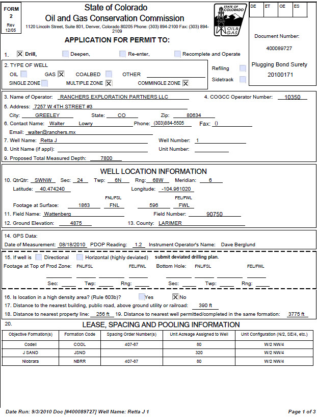
Application to Drill (approved)
Well Location Platform
Image
Retta J#1
click to enlarge
CLICK ON THE IMAGE TO ENLARGE
Well Name/No: Retta J
#1 (click well name for
production)
Operator: RANCHERS
EXPLORATION PARTNERS LLC - 10350
Status Date: 9/30/2010
9:16:26 PM Federal or State Lease #:
County: LARIMER #069 Location: SWNW 24 6N
68W 6 PM
Field: WATTENBERG - #90750 Elevation: 4,875 ft.
Planned Location
1890 FNL 682 FWL Lat/Long: 40.47417/-104.96072 Lat/Long Source: Field Measured
Wellbore Data for Sidetrack #00
Status: XX 9/3/2010
Spud Date: 4/21/2012 Spud Date is: NOTICE
Wellbore Permit
Permit #: Expiration
Date: 9/29/2012 9:16:26 PM
Prop Depth/Form: 7800 Surface Mineral Owner Same: Y
Mineral Owner: FEE Surface Owner: FEE
Unit: Unit
Number:
Formation and Spacing: Code:
CODL , Formation: CODELL , Order: 407-87 , Unit Acreage: 80, Drill Unit: W/2
NW/4
Formation and Spacing: Code:
JSND , Formation: J SAND , Order: UNSPACED , Unit Acreage: 80, Drill Unit:
W2NW4
Formation and Spacing: Code:
NBRR , Formation: NIOBRARA , Order: 407-87 , Unit Acreage: 80, Drill Unit: W/2
NW/4
Casing: String Type:
SURF , Hole Size: 12.25, Size: 8.625, Top: , Depth: 400, Weight: 24
Cement: Sacks:
240, Top: 0, Bottom: 400, Method Grade:
Casing: String Type:
1ST , Hole Size: 7.875, Size: 4.5, Top: , Depth: 7800, Weight: 11.6
Cement: Sacks:
294, Top: 6627, Bottom: 7800, Method Grade:
please comment


No comments:
Post a Comment
WTFrack.org is a medium for concerned citizens to express their opinions in regards to 'Fracking.' We are Representatives of Democracy. We are Fractivists. We are you.